

Sven from Summit Mountaineering is back with some field tested advice on how to get “unlost” (or avoid getting that way in the first place!). This piece is also featured in the UK Association of Mountaineering Instructor’s magazine. Enjoy!
————————————————————————-
“Right grid reference, wrong map?!”
A wrist watch altimeter offers a more reliable method of sensing altitude than GPS which can be inaccurate under trees, near cliffs or building and in close proximity to some radios. It also provides a much more useful and quicker method of [re]location when used in conjunction with a traditional map and compass.
Barometric altimeters don’t actually measure altitude directly; rather they are constantly measuring the relative pressure in the atmosphere around us and comparing it against the pressure at sea level, in order to calculate the altitude (above sea level). Physics dictates that the higher up we go, the lower the pressure around us becomes, due to the reduced mass of gas and suspended molecules weighing down upon us: The air pressure. Pressure can also change however due to relatively high and low pressure bodies of air, move around the earth (causing weather). When calculating our height from this method, we must account for these changes by recalibrating from time to time against known heights (from the map), ideally throughout the mountaineering day and ALWAYS before we are lost or might need to calculate our height! It is a good habit therefore to calibrate your altimeter in the car park, on the summit and any other positively identified points in between, such as track/stream junctions or trig points.

-Credit Rajen Nathwani
So, we know how high we are but how does that help us with navigation?
You may already be familiar with the principles of a ‘triangular resection,’ the technique of identifying three points (or more) on both the map and the ground: The navigator takes a bearing to the known point (e.g. a church spire or the corner of a wood in the distance) and then converts it to a back-bearing by adding or subtracting 180 degrees. This bearing is then plotted on the map from the known point. You repeat this from three points and where the lines dissect, is your location.
A much more useful technique, due to the short time and effort it takes, is the ‘linear resection.’ That is, if you are on a linear feature such a road, track, edge of a forest, or even a ridge, then all you need to do is identify a single known point and plot that back to where it crosses your linear feature. You now know exactly where you are.  A great technique clearly, but obviously it only works on a linear feature right? This is where we all raise a glass to Nevil Maskelyne and friends, who whilst trying to measure the size of the earth by conducting experiments on Schiehallion, invented what are now known as contour lines. What Maskelyne et al found by accident, mean that we are now always on a linear feature – a contour line; all we have to do is find our altitude to tell us which one we are on…
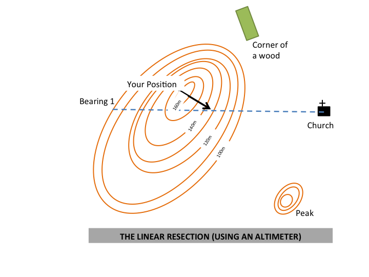 Have you ever used a technique like this, or wish you would have thought of it in a pinch? Share your thoughts in the comments below!
Fire Up | Get Dirty | Scare Yourself | Bleed
Do More Than Just Survive… Thrive!
———————————————————
About the Author
Graham ‘Sven’ Hassall is a freelance writer and mountaineering instructor (MIA & WML) based in the beautiful Wye Valley. A self confessed new-routeaholic, he is responsible for a couple of notable first ascents (and plenty of very forgettable ones!). He has climbed all over the world but most notably in the Himalayas, Africa and Europe. Of late he has turned his focus closer to home and two young climbers partners aged two and four!
Sven is available for mountaineering instruction and writing commissions.


You can tell he’s from the UK ’cause he uses the word “whilst.” =)